Quantifying NPS Pollutant Discharges from an Urbanizing Headwater Basin

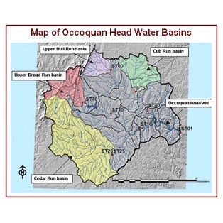
This research evaluated nonpoint source (NPS) sediment and nutrient fluxes from four headwater basins in the Piedmont physiographic province of the Chesapeake Bay drainage for up to 24 years. The basins are part of the Occoquan River watershed in northern Virginia. Three of the basins are predominantly forest and/or mixed agriculture. The fourth basin, Cub Run watershed, is rapidly urbanizing with approximately 50% of current land area classed as urban.
Results show that increased discharges and NPS fluxes were most responsive to increased rainfall and urbanization during winter and spring seasons, likely due to reduced natural ground cover and evapotranspiration. Cub Run basin was found to have the highest annual NPS sediment and nutrient flux of all headwater basins starting from 1983, when rapid population growth and massive land development began.


