

Urban Biodiversity in Holmes Run/Cameron Run Watershed
The Urban Biodiversity Information Node pilot (UrBIN), part of the National Biological Information Infrastructure, aims to provide communities with the information and tools needed to proactively manage urban natural resources. UrBIN’s goal is to serve a coordinating role in the delivery of standards, tools, and techniques necessary to find and make use of biological resources information, as communities establish urban natural resources programs.
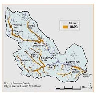
One component of the Holmes Run/Cameron Run Watershed study was landscape characterization and spatial analysis. The goal was to understand what urban biodiversity meant in this watershed. Some of the steps in this process were creating a landscape inventory and assessment, a review of physical and biological conditions in the watershed as well as demographics and land use, and developing spatial analyses using GIS identify interesting patterns and trends at the watershed scale.
See our Previous Projects
