

New River Valley Water Authority Study for Expansion South of U.S. I-81
For this project, CGIT's main objectives were to digitize and model the proposed regional water distribution system. With assistance from the New River Valley's Planning Commission (PDC) and Virginia Tech's Institute for Policy Outreach (IPO), block projections were created for the expansion area using 2000 census block data.
GIS software allowed for the display of population trends and graphic analysis. Tank locations were selected based on existing and projected population data as well as local knowledge.
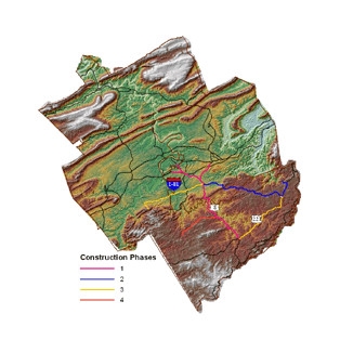
Water lines will supply four main service areas, located in Check, Riner, Radford, and Southern Pulaski Counties. Preliminary estimates showed service to 64.500 individuals. This estimate was a combination of Pulaski, Montgomery, and Floyd Counties over all four construction phases.
See our Previous Projects
